Point Formats
Icon: |
Introduction
Point Fomats describe COGO Point Properties and are critical to interpreting incoming files, formatting point descriptions and managing outputs. Point Formats manage three processes:
-
Import Points. The Point Format describes the columns of data in an incoming file, as they should apply to the properties assigned to created points (this for would be for parameters such as point number, easting, northing, elevation, full description)
-
Point Code Sets. Users can format the full Description of a point after/as it is inserted in the drawing, to assign additional parameters based on the format of the Description (such as interpreting a description of 'TR 5 45' as a Code of TR, having a Scale of 5 and a Rotation of 45). The formatted parameters from the Description can be used to manage this display or textual information for the applied Point.
-
Point Groups. Users can export COGO Points (in a Point Group) to an external file. As part of the export process users choose the point properties to include (as columns of data) in the export by by assigning a Point Format. Typically this would match up with the format used for importing files, however could also include parameters such as chainage, offset, alignment that could be stored on a point representing a string design
What is a COGO Point Property?
COGO Point Properties identify and describe each COGO Point. Properties of a point may include:
-
Core information about the point such as Point Number, Easting, Northing, Elevation, Description, Scale and Rotation
-
Optional information such as alignment, chainage and offset (for a design point associated with an alignment or string)
-
User information that is manually assigned to the point, such as the date the point was created
The Point Property List is common throughout the software and provides users with the ability to manage the display and inclusion of all Point Properties for the points.
Using Point Formats for Importing/Exporting Point Data
At the time of importing/exporting Points, the Point Format delivers the columns of data in the input/output.
Typically users are only importing the full Description of the point in this case, along with key/core parameters such as Point Number, Easting, Northing, Description. The Point Code Set is then used to split the full Description into components to manage display/scale/rotation of the COGO Point.
Users are encouraged to open any file intended for import, using Notepad or equivalent, to interpret the point information provided on each line. It is critical to establish what each field represents and confirm how it is delimited. Then a Point Format can be created to suit.
Point Formats for import/export will typically be named based on the columns of data being imported and the delimter (eg: P,E,N,Z,D would be a format to match a file describing the point number, easting, northing, elevation and description with each of these parameters separated by a comma. One line would describe one COGO Point.
Using Point Formats for Managing the Point Description
The incoming Point Description can be formatted by applying a Point Format in the Point Code Set. This would occur on the basis that the Point Description matches a Code in the Point Code Set. This can also be applied whenever the Point Style is edited for point/s in the drawing.
An imported point with description of, say TR 5 45, could be interpreted by the software in the following way via a Point Format being applied:
-
The point Code is TR so should have a 'tree' Point Style assigned
-
After the space, the 5 represents the diameter/radius of the tree so should be considered as the Scale to apply to the Point (this would be the User Scale point parameter)
-
After the next space, the 45 represents the rotation of the tree (relative to the WCS) so should be considered as the Rotation to apply to the Point (this would be the User Rotation point parameter)
Naming Point Formats
It is strongly recommended to name the Point Formats based on their intended use - unexpected results will occur if a Point Format is applied for a different use to that intended (in this case, only Point Formats that describe the way the point Description should be formatted should be applied). A number of default Point Formats are created with this intent - they all start with the name 'Description'.
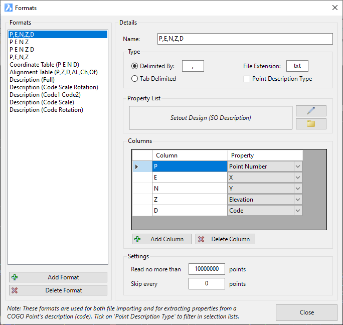
Details
Upon selecting the command the following form is displayed:
|
|
|
|
Formats |
This lists all created Formats and allows creation/deletion of Formats. |
|
[List of Formats] |
List of created Point Formats. Click on a Point Format to set it for editing on the right hand side of the form. |
|
Add Format |
Click to add a new Point Format. A default Name will be assigned and will display in the Details for editing. |
|
Delete Format |
Deletes the highlighted Point Format from the Point Formats list. |
|
Details |
The Right Hand Side of the form provides functionality to edit the selected Format in the Format List |
|
Name |
This is where the Name of the Point Format is edited. |
|
Type |
Establishes the type of separator between Point Properties (Character/s or tab). |
|
Delimited By |
Click to select this method. |
| File Extension | Type in a file extension - this is used when exporting COGO points to file |
| Tab Delimited | Click to select this method. If selected, the software will look for a tab input in the file as the separator between Properties Note: Activating this Format Type will automatically disable the Delimited By Comma/Space Format Type. |
| Point Description Type | Tick on to set the format to be applied to the interpretation of the Point Description (rather than being for import from file) |
|
Property List |
Here users can establish what Properties are available for inclusion in the Point Format. This is done by editing the Point Property List for the selected Point Format |
|
List Name |
Non editable information field list. If a name is displayed here, then point properties have been set up. The Name of the property list isn't critical as they are uniquely created for each Point Format |
|
|
Create/Edit the Point Property List for this Point Format. Here, users include point Properties (fields) for use in the Point Format. The property list allows manages the headings assigned to each Property and the how the data is stored (such as the number of decimal places) |
| |
Users can save the contents of the Point Property List to file. This can save time when setting up the same point properties in other forms where users establish the available point properties to use. Click this button to open a browser to load a saved Point Property List file (extension .ppl). This will assign point properties. |
|
Columns |
This sets up the Properties to use in the Point Format. |
|
[List of Columns] |
Lists the columns and their associated Property. Type in a name for the column and use the pick list to select a Property to display/apply |
| |
Click the Add Column button to add a customisable column to the columns list. |
| |
Click the Delete Column button to remove a column from the columns list. |
| Settings | The Settings manage how files are imported to created Points (the Import Points command). |
| Read no more than | Type in a value to represent the maximum number of lines of data to read from the file. These settings are most relevant to the Import Points command. |
| Skip every | Type in an integer value. After including a line in the import file skip this number of entries before including the next entry. eg: if the value 9 was typed in, the first entry woudl be added, the next 9 entries skipped and then 10th entry added, etc These settings are most relevant to the Import Points command. |
|
Close |
Close the form. |