Civil 3D Points Link
Icon: |
|
| Ribbon (Civil Site Design): | Survey Tab > Civil 3D COGO Points Panel > Civil 3D Points Link |
| Ribbon (Stringer Topo): | Site Tab > CSD/Civil 3D COGO Point Tools > Civil 3D Points Link (Civil Site Design) |
Introduction
This software can add additional information to Civil 3D Points as well as undertake various operations on the points, such as applying a transform, editing codes, editing point geometry (including creating a dynamic link to other objects), apply multiple symbols and more.
In order to apply these functions to Civil 3D points, it is required to create a link between the Civil 3D Point Group and this software.
This command lets users control which Civil 3D Points are linked to this software for edit control.
Creating Survey Strings automatically creates a Civil 3D Points Link
If the Create Survey Strings command is executed and a Civil 3D Point Group selected, then a link is automatically created between that Civil 3D Point Group and this software.
This command only needs to be run if there is no Survey Strings created and it is required to edit the Civil 3D points only..
Details
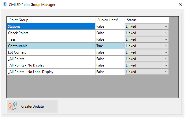
Upon selecting the command the following form is displayed:
 |
|
|
Point Group |
Lists all the Civil 3D Point Groups |
|
Survey Strings |
If Survey Strings have been created for the point group, this field will be set to True and the whole row will be highlighted with a blue background. |
| Status | Set to Linked to build a connection between point functionality in this software and Civil 3D points in the Point Group. |
| Create/Update | Apply these links and close the form |